The Limpopo Water Accounting Dashboard provides an interactive platform to explore, analyze, and visualize key water resources information across the Limpopo River Basin.
Developed to support evidence-based decision-making, it summarizes essential components of the basin’s water resources, including water availability, balance, and seasonal variations.
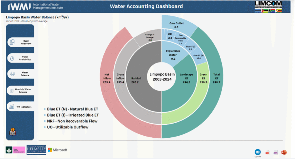
By integrating geospatial data and modeling outputs from the SIWA+ framework, the dashboard offers insights into rainfall, evapotranspiration, runoff, and storage dynamics from 2003 to 2024.
It enables stakeholders and policymakers to better understand spatial and temporal water distribution, assess water stress, and guide sustainable management practices within this transboundary basin.
Key Features
- Interactive Visualization
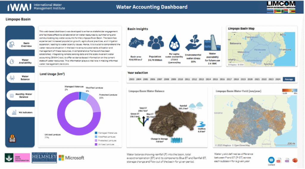
Explore spatial and temporal variations in key water indicators including water availability, evapotranspiration, rainfall, and water yield across the Limpopo Basin through dynamic maps and charts. - Comprehensive Water Balance Analysis
Presents a detailed view of key hydrological components including rainfall, total evapotranspiration, outflow, ET values, and storage change to assess the basin’s water dynamics. - Water Availability Analysis
Displays water availability per capita across years and months, revealing patterns of variability and water stress. Includes agriculture, irrigated, and managed ET fractions, basin closure rates, and available water for further use, helping users assess how efficiently water is being utilized within the basin. - Land Use and Basin Indicators
Provides insights into land cover distribution (utilized, protected, modified, and managed areas) and basin statistics such as population, area, per capita availability, and environmental water stress levels. - Temporal and Seasonal Insights
Allows users to compare seasonal and annual trends (2003–2024) to understand hydrological shifts between wet and dry seasons, as well as long-term climatic variations influencing water availability. - Evidence-Based Decision Support
Integrates data derived from the SIWA+ model, empowering policymakers, researchers, and basin managers with reliable information for sustainable and equitable water management.
The Limpopo Water Accounting Dashboard serves as an essential decision-support tool for understanding and managing the basin’s shared water resources. By integrating satellite observations, hydrological models, and spatial analysis, the platform provides a holistic view of water availability, use, and balance across four riparian countries. It enhances transparency, promotes collaboration among stakeholders, and supports evidence-based planning to ensure the sustainable utilization of water resources for people, ecosystems, and economies within the Limpopo River Basin.